
How to Become a Cartographer & GIS Specialist in 2026
Is Cartographer & GIS Specialist Right for You?
The U.S. Department of Labor's O*NET profile for Cartographers and Photogrammetrists (SOC 17-1021) describes the work this way: Research, study, and prepare maps and other spatial data in digital or graphic form for one or more purposes, such as legal, social, political, educational, and design purposes. May work with Geographic Information Systems (GIS). May design and evaluate algorithms, data structures, and user interfaces for GIS and mapping systems. May collect, analyze, and interpret geographic information provided by geodetic surveys, aerial photographs, and satellite data.
What the work involves
- Compile data required for map preparation, including aerial photographs, survey notes, records, reports, and original maps.
- Delineate aerial photographic detail, such as control points, hydrography, topography, and cultural features, using precision stereoplotting apparatus or drafting instruments.
- Prepare and alter trace maps, charts, tables, detailed drawings, and three-dimensional optical models of terrain using stereoscopic plotting and computer graphics equipment.
- Study legal records to establish boundaries of local, national, and international properties.
- Inspect final compositions to ensure completeness and accuracy.
Skills and knowledge that matter
Skills: Reading Comprehension, Writing, Critical Thinking, Active Listening, Active Learning, Speaking.
Knowledge: Geography, Computers and Electronics, English Language, Design.
Tools and technology you may use
Technology: Document management software, Graphics or photo imaging software, Web page creation and editing software, Adobe Acrobat, Adobe Creative Cloud software, Adobe Illustrator.
Typical preparation
O*NET Job Zone Four (Considerable Preparation Needed). Most of these occupations require a four-year bachelor's degree, but some do not. Employees in these occupations usually need several years of work-related experience, on-the-job training, and/or vocational training.
Interest fit
O*NET interest profile: Conventional, Investigative, Realistic. People who enjoy structured, detail-oriented work with clear procedures and data often find this occupation a good fit.
Source: O*NET 31.0 (updated 2026-10-14)
Quick answer: Training as a cartographer requires a 4-year degree - typically a Bachelor’s in geomatics, geography/GIS, or surveying. The national median pay is $81,390 per year, and BLS projects +7.4% employment change from 2025 to 2035 (BLS OEWS, May 2025; BLS Employment Projections, 2025-35).
Cartographer & GIS Specialist at a Glance
| Metric | Detail | Source |
|---|---|---|
| Median annual wage | $81,390 | BLS OEWS, May 2025 |
| Typical wage range | $53,740 (10th pct) - $126,950 (90th pct) | BLS OEWS, May 2025 |
| Employment | 14,260 nationwide | BLS OEWS, May 2025 |
| Projected growth (2025-35) | +7.4%, about 900 openings per year | BLS Employment Projections, 2025-35 |
| Typical education | Bachelor’s in geomatics, geography/GIS, or surveying | BLS Occupational Outlook Handbook |
| License / certification | Photogrammetrist licensure in some states; GISP certification valued | State licensing boards |
What Does a Cartographer & GIS Specialist Do?
Cartographers and photogrammetrists turn survey data, drone imagery, and LiDAR into authoritative maps and spatial databases - the office half of the measurement work survey crews perform in the field. They decide which data sources to trust, tie everything to the right coordinate system and datum, and produce the maps, orthophotos, and databases that engineers, utilities, and government agencies build on.
Day to day the work splits by sub-specialty. A cartographer designs and maintains map products: choosing projections, generalizing detail for scale, and keeping base maps and parcel layers current as new survey data comes in. A photogrammetrist extracts measurable geometry from aerial and drone imagery or LiDAR point clouds - elevation models, planimetric features, orthomosaics - then checks it against ground control to prove the accuracy claims. A GIS analyst lives on the database side: writing queries against spatial data, automating workflows in Python, and answering questions like where a utility’s aging mains are or which parcels a road widening will touch. In all three flavors the deliverable carries stated accuracy standards - the job is as much quality control and documentation as production.
If you are coming off a survey crew, a drone mapping operation, or utility locating, the shortest way to say it: you already know how the data is born - how a bad GPS fix, a leaning rod, or thin photo overlap corrupts everything downstream. This career moves you to the desk where that data gets adjusted, merged, and published, and field people consistently catch the errors classroom-trained analysts wave through. The degree converts your field judgment into authority over the finished product.
Skills That Make a Great Cartographer & GIS Specialist
- ArcGIS and QGIS mastery
- Photogrammetry workflows and ground-control validation
- LiDAR processing and point-cloud classification
- Cartographic design: projections, symbology, generalization
- Spatial database management (PostGIS, geodatabases) and SQL
- Coordinate systems, datums, and adjustment fundamentals
- Python scripting for automation - the single biggest pay separator in GIS job postings
- Writing: metadata, accuracy reports, and map documentation carry the deliverable
Cartographer & GIS Specialist Salary
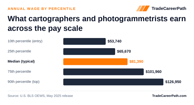
The national median for cartographers and photogrammetrists is $81,390 per year - solid degree-career pay for a genuinely accessible bachelor’s. The 10th percentile, roughly where GIS technicians and new graduates start, is $53,740; the 25th is $65,670. Experienced analysts and photogrammetrists reach $101,960 at the 75th percentile, and the 90th hits $126,950 - typically GIS managers and licensed photogrammetrists running programs (BLS OEWS, May 2025).
Where the Jobs and the Money Are
This is a small, government-and-utility-heavy occupation - 14,260 jobs nationwide - so where you live matters more than in bigger fields. The largest headcounts are in Texas (1,780 jobs at a $73,970 median), California (1,450 jobs), and Colorado (1,220 jobs at $86,960). Colorado is the true hub: cartographers are about 4.6 times as concentrated there as in the average state labor market, driven by federal mapping agencies along the Front Range (BLS OEWS, May 2025).
| State | Median annual wage | Employment |
|---|---|---|
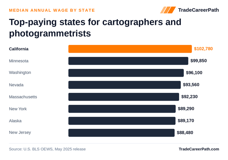
| California | $102,780 | 1,450 |
| Minnesota | $99,850 | 100 |
| Washington | $96,100 | 870 |
| Nevada | $93,560 | 180 |
| Massachusetts | $92,230 | 160 |
Washington offers both: a $96,100 median plus a concentration about 2.7 times the national average - a deep enough market to change employers without relocating. California pays the most outright at $102,780. Minnesota and Massachusetts pay well but employ few - 100 and 160 jobs respectively - so treat those medians as what a handful of positions pay, not evidence of a big market.
How to Become a Cartographer & GIS Specialist
1. Build field data experience
Survey crew, drone mapping, or utility locating work supplies the spatial foundation. Time on a total station or a GNSS rover is directly relevant here - you already understand control networks, closure, and why field notes matter. If you are still in the field, start collecting the office-side tasks now: process your own drone flights, handle the data downloads and adjustments, take the CAD and GIS cleanup work nobody else wants. That becomes the portfolio that gets you the first analyst interview.
2. Earn the bachelor’s degree
Geomatics, geography with GIS, or surveying. Geomatics is the measurement-science route and keeps the photogrammetrist and surveyor licensure doors open; geography with a GIS concentration has the most online options and points at analysis roles. Get a written transfer evaluation before enrolling anywhere - prior college, military geospatial training, and surveying coursework are commonly worth meaningful credit at transfer-friendly schools.
3. Master the toolchain
ArcGIS/QGIS, photogrammetry suites, and LiDAR processing. The degree teaches concepts; employers hire for the stack. Esri’s ArcGIS Pro is the government-and-utility standard, QGIS covers everything else, and drone photogrammetry plus LiDAR classification tools round out the production side. Learn enough Python to automate a repetitive workflow - it is the clearest dividing line between technician pay near $53,740 and the $81,390 analyst median.
4. Start in GIS analysis or mapping production
Government agencies, utilities, and engineering firms are the major employers. County GIS departments, state DOTs, and federal mapping agencies hire steadily and value field-experienced candidates; utilities need people who understand what is actually buried where; engineering and surveying firms hire on the photogrammetry and mapping-production side. From a survey background, the surveying-firm route is usually the easiest first job - your references already speak the language.
5. Advance
GIS manager, photogrammetrist (licensed in some states), or geospatial program lead. The fork comes five to ten years in: deepen into licensed photogrammetry or LiDAR/remote-sensing specialization, or run a jurisdiction’s or utility’s geospatial program - the management track where 90th-percentile pay of $126,950 concentrates.
Career Ladder: Titles and Realistic Pay
The BLS wage percentiles map cleanly onto how geospatial careers actually progress. Use this as a sanity check on offers, not a guarantee:
| Stage | Typical titles | Years in | Realistic pay (BLS OEWS, May 2025) |
|---|---|---|---|
| Entry level | GIS technician, mapping technician, GIS analyst I | 0-3 | ~$53,740-$65,670 (10th-25th pct) |
| Mid-career | GIS analyst II, cartographer, photogrammetrist | 3-10 | ~$81,390 (median) |
| Senior | Senior GIS analyst, lead photogrammetrist, GIS coordinator | 10-15 | ~$101,960 (75th pct) |
| Principal / leadership | GIS manager, licensed photogrammetrist, geospatial program lead | 15+ | $126,950+ (90th pct) |
Two notes for career changers. First, survey and drone field experience compresses this ladder: former crew members are routinely hired above the bottom of the entry band because they can spot bad control on sight. Second, much of this occupation is public-sector, so compare total packages, not just base wage - pension, benefits, and job security at a county or state agency often outweigh a modestly higher private-firm salary.
Do You Need a License?
For most of this occupation, no. Cartographers and GIS analysts are not licensed - there is no state board standing between you and the work. Two credential paths do matter:
- Photogrammetrist licensure: some states regulate photogrammetry as part of surveying, so authoritative mapping there requires a license, typically through the state surveying board. If your plan includes stamped photogrammetric deliverables, check your state board’s rules early and lean toward the geomatics degree route.
- Voluntary certification: the GISP (GIS Professional) certification and the ASPRS certified photogrammetrist credential are the recognized industry markers. Neither is legally required, but the GISP shows up as “preferred” in many government GIS postings and helps at promotion time.
One boundary to respect: determining property lines is licensed land surveying everywhere. GIS parcel mapping supports that work but never replaces it - signing boundary work means the Surveyor path and its mandatory state PS license.
Why an Online Degree Works for This Career
Survey crew members and drone operators feed this career directly. Online GIS and geomatics bachelor’s programs (and GIS certificates stacked on an existing degree) are among the most established online geospatial credentials - the coursework is software-based, so it translates to online delivery better than almost any other technical degree. You can keep your field job, practice the toolchain on real project data, and graduate with a working portfolio alongside the credential.
Job Outlook for 2026 and Beyond
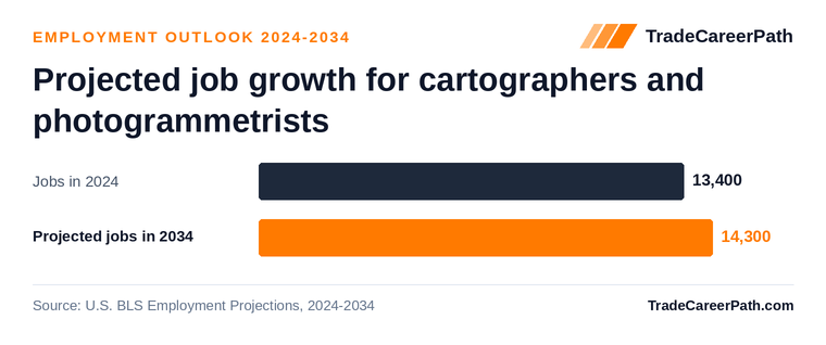
BLS projects employment of cartographers and photogrammetrists to grow +7.4% from 2025 to 2035 - from 14,700 to 15,700 jobs - with about 900 openings per year once retirements and occupation changes are counted (BLS Employment Projections, 2025-35). Wages are moving the right direction too: the projections dataset recorded a 2024 median of $78,380, and the May 2025 OEWS median is $81,390.
The demand drivers are steady rather than spectacular: governments keep expanding what they map, drone and LiDAR capture keeps getting cheaper - which creates more data needing skilled processing, not less - and an older public-sector workforce is retiring out. In a 14,260-person occupation, 900 openings a year is meaningful turnover. The honest caveat: it is a small field, and candidates willing to work where the jobs cluster (Texas, California, Colorado, Washington) will have a much easier search than those tied to a thin market.
Cost and Time to Complete the Degree
For cartographers and photogrammetrists, the credential is: Bachelor’s in geomatics, geography/GIS, or surveying. A bachelor’s degree is typically 120 credit hours: four years full-time, and commonly five to six years part-time while working. Transfer credit is the other lever: prior college, military training, apprenticeship coursework, and industry certifications can be worth meaningful credit at transfer-friendly schools, so get a written transfer evaluation before enrolling anywhere. Costs vary widely by school type; in-state public online programs are usually the value benchmark, and employer tuition assistance is common for working adults in this field. If you already hold a bachelor’s in anything, a GIS graduate certificate is a faster alternative many employers accept for analyst roles.
Pros and Cons of Training as a Cartographer & GIS Specialist
Pros
- Median pay of $81,390 nationally (BLS OEWS, May 2025)
- BLS projects +7.4% employment growth through 2035
- Field experience from the trades is a genuine hiring advantage
- Accredited online and hybrid degree paths exist for working adults
Cons
- Requires a 4-year degree (typically 120 credit hours)
- Entry-level pay starts near $53,740 at the 10th percentile
- Small occupation (14,260 jobs) concentrated around government and utility hubs
- Licensing hurdle: Photogrammetrist licensure in some states; GISP certification valued
Frequently Asked Questions
Can a survey technician move into GIS?
Yes - it is the standard office-side progression from field surveying, and the bachelor's in geomatics or GIS is the typical entry credential BLS lists for the occupation.
How much do cartographers and photogrammetrists make?
The national median annual wage for cartographers and photogrammetrists is $81,390 (BLS OEWS, May 2025). The top 10% earn $126,950 or more, while entry-level pay starts around $53,740.
What is the job outlook for cartographers and photogrammetrists?
BLS projects employment of cartographers and photogrammetrists to change by +7.4% from 2025 to 2035 (BLS Employment Projections, 2025-35).
How long does cartographer or GIS specialist training take?
The bachelor's in geomatics, geography/GIS, or surveying is 120 credit hours: four years full-time, commonly five to six years part-time while working. Survey techs with prior college or military geospatial training can often transfer in meaningful credit, and a GIS certificate stacked on an existing degree is faster still.
Is GIS hard to learn?
Less math-heavy than engineering - the core is coordinate systems, statistics, and database logic rather than calculus. The real learning curve is the software stack (ArcGIS, QGIS, LiDAR and photogrammetry tools), and field people who already understand how the data gets collected pick it up faster than classroom-only students.
Should I get a geomatics degree or a geography/GIS degree?
Geomatics leans toward measurement science - surveying, photogrammetry, LiDAR - and is the better fit if you may pursue photogrammetrist or surveyor licensure later. Geography with a GIS concentration has far more online options and points toward analysis and mapping roles. Both are accepted entry credentials for this occupation.
Can you work in GIS without a degree?
You can start as a GIS or mapping technician on experience plus a certificate, and pay at that level runs near the $53,740 10th percentile. The analyst, cartographer, and photogrammetrist titles - and the $81,390 median - typically require the bachelor's, which is the credential BLS lists for the occupation.
Do cartographers or GIS specialists need a license?
Cartographers and GIS analysts generally do not. Photogrammetrists must be licensed in some states, usually through the state surveying board. The voluntary GISP certification and the ASPRS certified photogrammetrist credential are the industry markers employers look for.
Cartographer & GIS Specialist Salary and Requirements by State
Alaska · Arizona · California · Colorado · Connecticut · Florida · Georgia · Idaho · Illinois · Indiana · Iowa · Kentucky · Louisiana · Maine · Maryland · Massachusetts · Michigan · Minnesota · Missouri · Montana · Nebraska · Nevada · New Hampshire · New Jersey · New Mexico · New York · North Carolina · North Dakota · Ohio · Oklahoma · Oregon · Pennsylvania · South Carolina · South Dakota · Tennessee · Texas · Utah · Virginia · Washington · Wisconsin · Wyoming
Related Careers and Degree Paths
- Surveyor - the licensed field-side counterpart; same data, boundary authority, PS license required
- Civil Engineer - the design discipline that consumes most mapping and GIS deliverables
- Geoscientist - earth-science analysis built on the same remote-sensing and GIS toolchain
- Environmental Scientist - GIS-heavy fieldwork-to-office path in the environmental sector
- All trade careers that require a 4-year degree
Degree and Program Guides
- Online Information Technology Degrees - the broader technology degree option
Degree and Program Guides
- Online Surveying Degrees - the licensed-surveyor route from GIS work
Sources
- U.S. Bureau of Labor Statistics, Occupational Employment and Wage Statistics (OEWS), May 2025 - Cartographers and Photogrammetrists (SOC 17-1021)
- U.S. Bureau of Labor Statistics, Employment Projections, 2025-35
- U.S. Bureau of Labor Statistics, Occupational Outlook Handbook - education and licensing requirements
Cartographer Gis Salary by State
About this guide: Researched and written by the TradeCareerPath Editorial Team. Our editorial team researches and sources every trade school and career guide using federal labor and education data, including BLS OEWS and Employment Projections, DOL apprenticeship records, IPEDS, College Scorecard, and state licensing boards. We follow the editorial standards documented at /editorial-policy/.
Data sources
Figures on this page are sourced from the federal and state datasets below. Methodology: how we rank and source data.
| Data | Provider | Vintage |
|---|---|---|
| Occupational Employment and Wage Statistics (OEWS) | U.S. Bureau of Labor Statistics | May 2025 |
| Employment Projections | U.S. Bureau of Labor Statistics | 2025-2035 |
| Integrated Postsecondary Education Data System | National Center for Education Statistics (IPEDS) | 2024 |
| College Scorecard (school-level outcomes) | U.S. Department of Education | latest release |
| College Scorecard (field-of-study earnings) | U.S. Department of Education | latest release (updated 2026-06-12) |
| Occupational licensing requirements | CareerOneStop (U.S. Department of Labor) | latest release (updated 2026-02-22) |
| Registered apprenticeship programs | CareerOneStop / Apprenticeship.gov (U.S. Department of Labor) | latest release (updated 2025-10-25) |
| O*NET occupation profiles (skills, tasks, tools, job zones) | U.S. Department of Labor (O*NET / Employment & Training Admin.) | O*NET 31.0 (updated 2026-10-14) |